
Last Monday I joined the Space Coast Birding and Wildlife Festival pelagic trip out of Ponce Inlet. This was my second trip on the Pastime Princess, following my first pelagic back in September 2011.
I wanted to try to track the trip on a map, so I looked into how to use the GPS on my iPhone without having network connection. I learned that if the area to be visited is cached in the iPhone’s native Maps app, the GPS will be able to find the present location on the map. (I am still on IOS 5.1.1 so I was using the iPhone Maps app powered by Google maps.) The day before the pelagic, I spent a few minutes zooming in and out of the Atlantic Ocean off the coast of Volusia and Brevard counties on my iPhone to get as much information into the cache as possible.
There are applications that can use cached maps in coordination with GPS to make a line that tracks a journey, but I figured this might be a battery drain. So instead, I planned to drop pins on the map as we went. However, I learned just a bit too late (on the boat, at sea!!) that the app won’t hold more than one pin. I could have saved locations as bookmarks, but that seemed cumbersome.
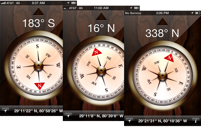
So, plan B. I checked our location every hour or so using the Maps app. It takes a few moments for the phone to fix a location using just GPS, so I had to be patient. Once I knew that our location was found, I went to the native Compass app and took a screenshot. At the end of the day I had a list of coordinates that I plugged into a Google map when I got home.
This map shows how we went. We actually started at Ponce Inlet which is by point N, but I didn’t start taking coordinates until we turned out to sea. For the first part of the trip we hugged the coast (so from N to A).
View Larger Map
This may be a very roundabout way of tracking the trip, but it worked great and I was pleased to see for myself how we went. Trip leaders often give out a very general idea of how the boat will travel, or the final mileage and approximate distance from the shore, but I think it’s neat to see more precisely how we traveled. The total journey from port to port was about 123 miles; at our furthest point we were about 48 miles offshore. And of course I was most pleased to see that we did not travel into Brevard waters, as was first indicated! 😀


One Response to Tracking a pelagic journey